Facebook uses AI to map Thailand’s roads
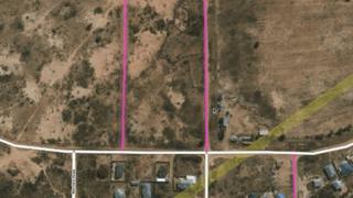
Image copyright
Facebook
White lines represent mapped roads, pink lines represent predicted ones
Facebook has used artificial intelligence (AI) to map 300,000 miles of previously unmapped roads in Thailand and made the results available to the public.
The project had been completed in 18 months, less than half the time it would have taken 100 mapping experts to do it manually, Facebook said.
The maps could be used for disaster response and urban planning.
Many parts of the world remain unmapped.
The tool used for the project, Map With AI, is now being made available to all and includes access to AI-generated maps of Afghanistan, Bangladesh, Indonesia, Mexico, Nigeria, Tanzania and Uganda.
Facebook plans to add more countries over time.
The AI system uses satellite images with a resolution of two sq ft per pixel to distinguish roads from walkways or rivers.
As part of the Thailand road-mapping project, human experts reviewed and corrected the road networks identified by the AI system.
Facebook’s desire to map the world is linked with its ambitions to expand rural internet access and add more users to its social network.
The project is a collaboration with OpenStreetMap (OSM), built by a community of mappers who maintain data about roads, railways stations and other services around the world.
Talking about the new AI tool, Martijn van Exel, a long time contributor to OSM, said: “This is definitely going to be a key part of the future of OSM.
“We can never map the world, and keep it mapped, without assistance from machines.
“The trick is to find the sweet spot.
“OSM is a people project and the map is a reflection of mappers’ interests, skills, biases, et cetera.
“That core tenet can never be lost but it can and must travel along with new horizons in mapping.”